|
Kartensammlung 1
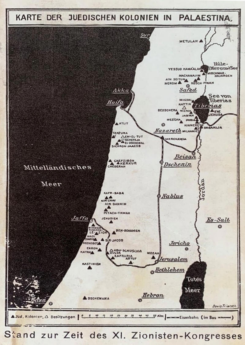
EIN KLEINES STÜCK GESCHICHTE. DIE KARTE DER JÜDISCHEN KOLONIEN
IN PALÄSTINA. Diese Karte ist von 1913 und stammt aus dem
jüdischen Museum in Wien. Man kann daraus zwei Dinge ableiten,
erstens, dass sich die Zionisten lange vor 1948 völlig bewusst
waren, dass sie daran arbeiten, ein Gebiet zu kolonisieren, und
zweitens, dass sie sehr wohl wussten, dass das Land, das sie
kolonisieren wollten, Palästina hieß. Genau das, was die
umgeschriebene Version der Geschichte Israels lieber beschönigt.
Die
Palästinensische Geschichte - Gestohlenes Land - Eine
interaktive Karte
Um
die interaktive Karte zu ereichen auf das Bild klicken

Karte zum Vergrößern anklicken
Karte zum Vergrößern anklicken

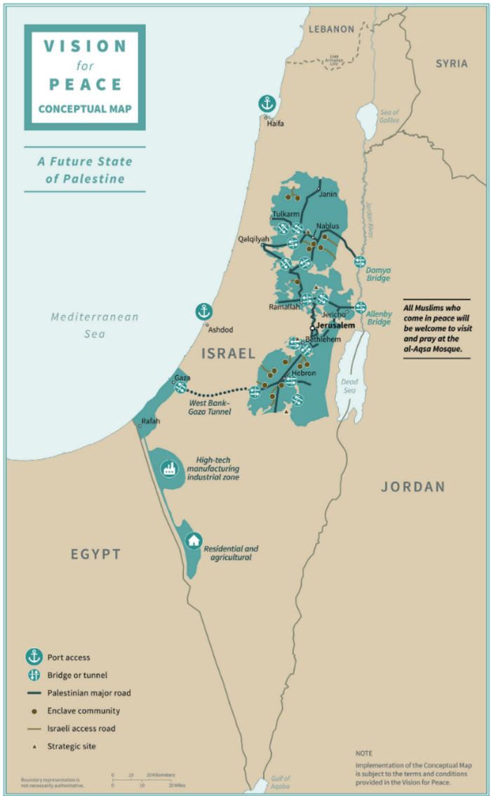
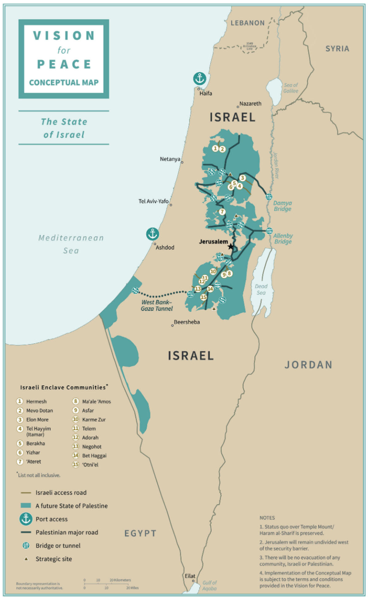
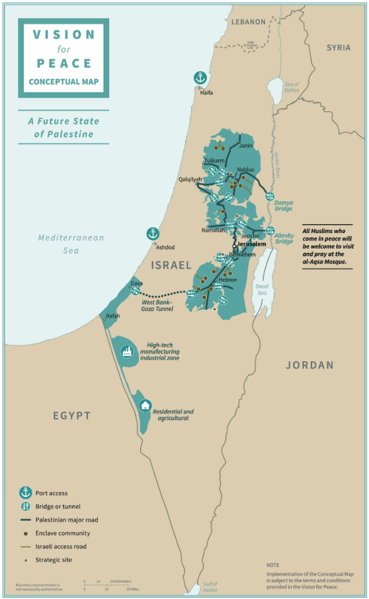
"Friedensplan" von Trump
Karte
zum Vergrößern anklicken
Karte
zum Vergrößern anklicken
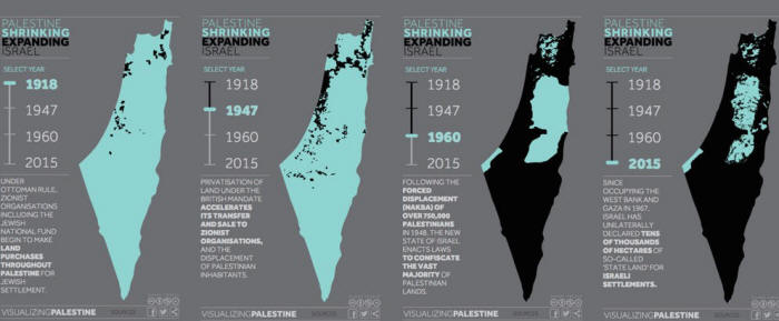
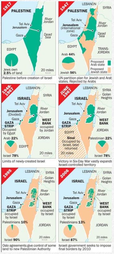
Palästina und Israel: Kartierung einer Annexion
Wie werden die Karten von Palästina und Israel aussehen,
wenn Israel am 1. Juli das Jordantal illegal annektiert?
Mohammed Haddad - 26 Jun 2020 - Übersetzt
mit DeepL
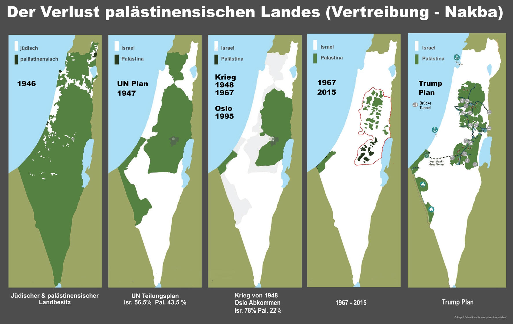
Die aktuelle Karte
von Palästina wird oft als "Schweizer Käse" beschrieben. Im
vergangenen Jahrhundert wurde sie zerstückelt, eingemauert und
mit Hunderten von illegalen israelischen Siedlungen und
Militärkontrollpunkten gefüllt.
Jetzt, in der jüngsten Runde der anhaltenden israelischen
Besetzung und der Politik der Landnahme, könnte diese Karte noch
unzusammenhängender werden. Es wird erwartet, dass der
israelische Premierminister Benjamin Netanjahu am 1. Juli die
Annexion des Jordantals und des nördlichen Toten Meeres durch
Israel verkündet.
Annexion ist ein Begriff, der verwendet wird, wenn ein Staat ein
anderes Gebiet innerhalb seiner Grenzen einseitig annektiert.
Die Annexion des Jordantals würde bedeuten, dass Israel es
offiziell als Teil des Staates Israel betrachten würde.
"Das internationale Recht ist sehr klar: Annexion und
territoriale Eroberung sind durch die Charta der Vereinten
Nationen verboten", sagte Michael Lynk, der unabhängige
UN-Experte für Menschenrechte in den palästinensischen Gebieten.
Um zu verstehen, wie die Annexion vor Ort aussehen wird und wie
wir hierher gekommen sind, hat Al Jazeera eine Sammlung
historischer und aktueller Karten zusammengestellt, die Sie
erkunden können.
Quelle
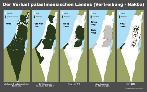
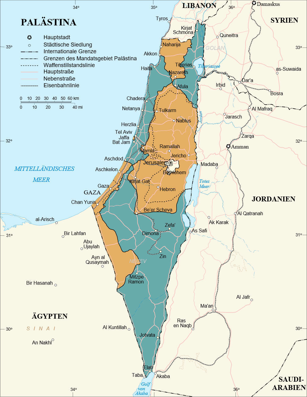
Der
UN-Teilungsplan von 1947
Palästina in orange, Israel in grün:
Zu vergrößern auf das Bild oben klicken
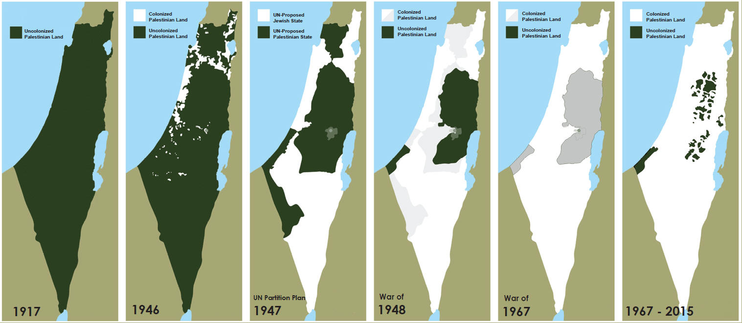
Historic
maps:
-
1917 - Pre-British Mandate Palestine
-
1918-1947 - Jewish immigration from Europe
-
Chart: 1920-1946 - Jewish immigration to Palestine
-
1947 - Proposed UN Partition Plan (Resolution 181)
-
1948 - Palestinians expelled
-
1967 - Israel occupies Gaza and the West Bank
-
1993 & 1995 Oslo Accords
Present-day
maps:
-
How big are Palestine and Israel?
-
Occupied Palestinian territories
-
Israeli settlements
-
Chart: Israeli settler growth
-
Separation wall
-
Israeli checkpoints
-
Palestinian refugee camps
-
Israel's history of annexations
-
Jerusalem, the divided city
-
The Old City of Jerusalem
-
Al-Aqsa Mosque
-
Occupied Golan Heights
-
Jordan Valley
-
Israel's annexation of the Jordan Valley
-
Trump's conceptual map
-
Jordan Valley annexation: Trump vs Netanyahu
-
Blockade of the Gaza Strip
-
Where are the Palestinians today?
-
Where are the Jews today?
-
International recognition
Trumps "Friedensplan" - Der «Jahrhundertdeal
Karten, Technologie und dekoloniale Raumpraktiken in Palästina
von Zena Agha am 14. Januar 2020
Zusammenfassung
- Die Praxis der Kartierung in Palästina-Israel war lange Zeit
eine Übung in Macht, Imperialismus und Enteignung. Die
Al-Shabaka-Politikanalytikerin Zena Agha untersucht, wie
Palästinenser vom britischen Mandat bis heute von Karten ihres
eigenen Landes ausgeschlossen wurden, und untersucht, wie
Palästinenser Karten als Mittel des Widerstands zurückfordern
können - und dies auch tun.
Übersicht - Die Praxis der Kartierung in Palästina-Israel
war lange Zeit eine Übung in Macht, Imperialismus und
Enteignung. Seit dem britischen Mandat bis heute haben
zionistische (später israelische) Kartographen Karten benutzt,
um physische, geographische und soziale Markierungen der
Verbindungen der Palästinenser zum Land und ihres Besitzes zu
verdunkeln und auszulöschen.
Das Aufkommen der Technologie des Global Positioning System
(GPS), der Software für Geographische Informationssysteme (GIS)
und die steigende Anzahl von Fernerkundungssatelliten in den
letzten Jahrzehnten ermöglichte die genaue und umfassende
Kartierung des Mandatsgebiets Palästina. Stattdessen fahren die
Herausgeber von Satellitenbildern, einschließlich Google, fort,
die Präsenz Palästinas auszuhöhlen, indem sie entweder Bilder in
niedriger Auflösung veröffentlichen, falsche Routenoptionen für
Palästinenser vorschlagen, ungenaue und/oder hebräische
Ortsnamen kennzeichnen oder einfach Gebiete, die von
Palästinensern bewohnt sind, leer lassen - ein gepixelter Terra
Nullius.
Dieses Kurzdossier untersucht die verschiedenen Arten, wie
Palästinenser von den Karten ihres eigenen Landes ausgeschlossen
wurden, vom Beginn des britischen Mandats bis heute. Es
argumentiert, dass schlecht kartierte Orte das Raumverständnis
der Palästinenser verändern und sie von ihrem Heimatland
entfremden. Sie untersucht auch alternative, subversive Karten
als Mittel, um die Vergangenheit zu erkennen, die Gegenwart zu
bewerten und sich die Zukunft vorzustellen. Sie kommt zu dem
Schluss, dass Karten, obwohl sie eng mit dem britischen und
israelischen Kolonialismus verbunden sind und konsequent als
Vehikel der Auslöschung benutzt werden, als Ausdruck der
geographischen Imagination und als Mittel des Widerstands
zurückerobert werden können.
Koloniale Kartographie
Trotz ihres Anspruchs auf einen mathematischen Realismus
spiegeln moderne Karten nicht einfach die Realität wider: Sie
schaffen und verankern eine bestimmte Wahrnehmung der Erde, auf
der wir leben. Die auf einer Karte gezeichneten Linien trennen
Länder von den Ozeanen und voneinander. Der Bereich zwischen den
Linien repräsentiert konstruierte sozio-politische Einheiten des
souveränen Raums: Nationalstaaten. Trotz des Prozesses der
Staatsgründung und des Zerfalls an Orten wie Palästina, Sudan
und Tibet werden die Nationalstaaten in der internationalen
Ordnung als feste Einheiten akzeptiert. In zeitgenössischen
Kartenprojektionen, die die dreidimensionale Oberfläche der Erde
auf einer zweidimensionalen Ebene darstellen, werden
Nationalstaaten als definitive, objektive und
selbstverständliche Markierungen der politischen Realität
dargestellt - eine Fassade, die durch Nutzer, die mit
politischen Karten interagieren, als perfektes, maßstabsgetreues
Abbild des Raums verstärkt wird.
weiter im englischen Text mit Karten >>>
Die nachfolgenden
Karten sind nicht immer im Detail korrekt, manche sind aus einer
bestimmten pol. Position heraus entstanden.
Bei einem Staat wie Israel, der keine Staatsgrenze angibt und
siehe die Seite
"Wo ist Palästina", der tagtäglich mit seiner
Siedlungspolitik neuen Landraub begeht ist es auch schwer
korrekte Grenzen anzugeben.
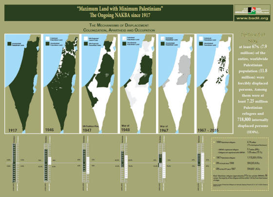
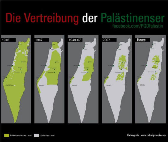
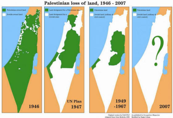
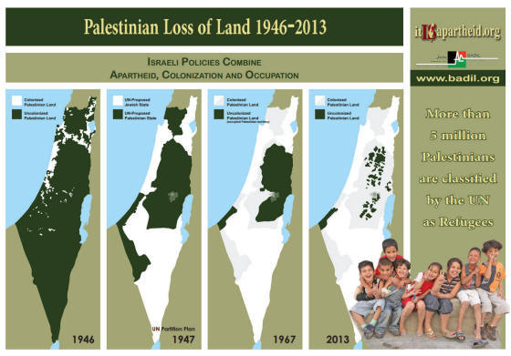
International wird einmal die UN Teilungsgrenze von 1947 und
nachfolgend die Grenzziehung zum Oslo Abkommen 1967 als Grenze
angegeben.

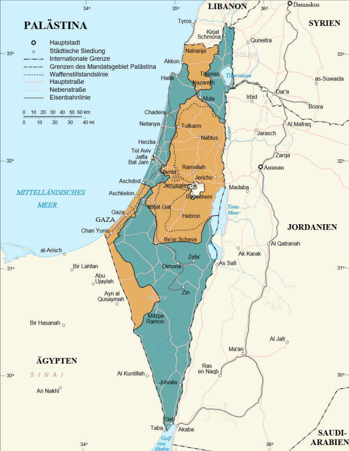
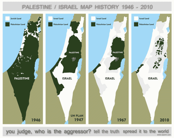
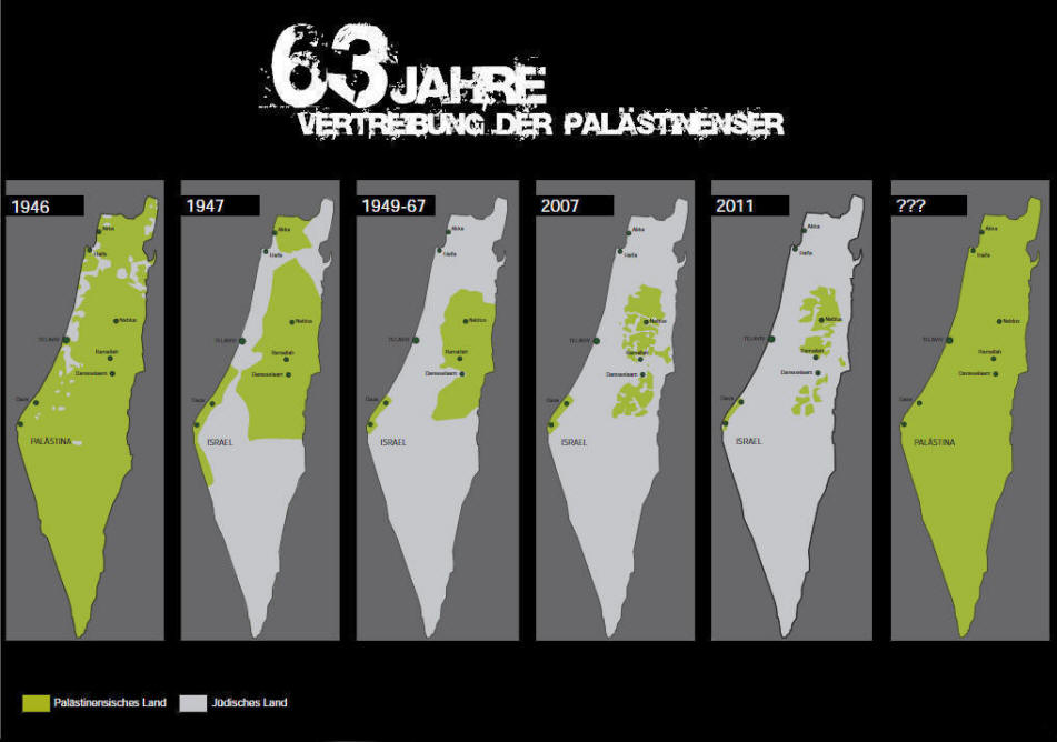
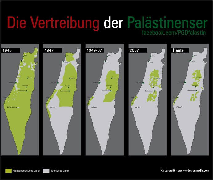
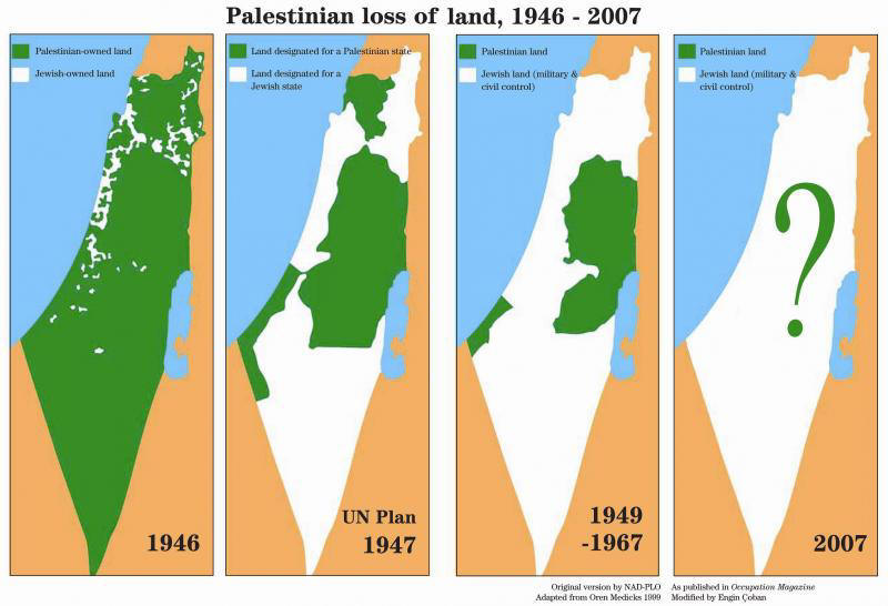
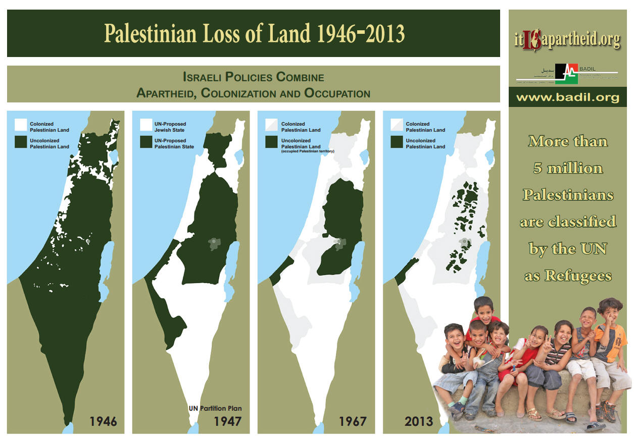
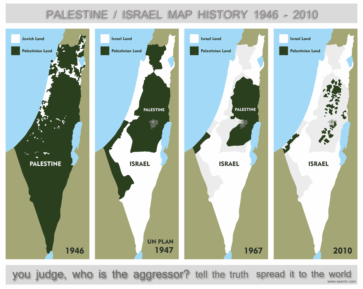
Karte zum Vergrößern
anklicken

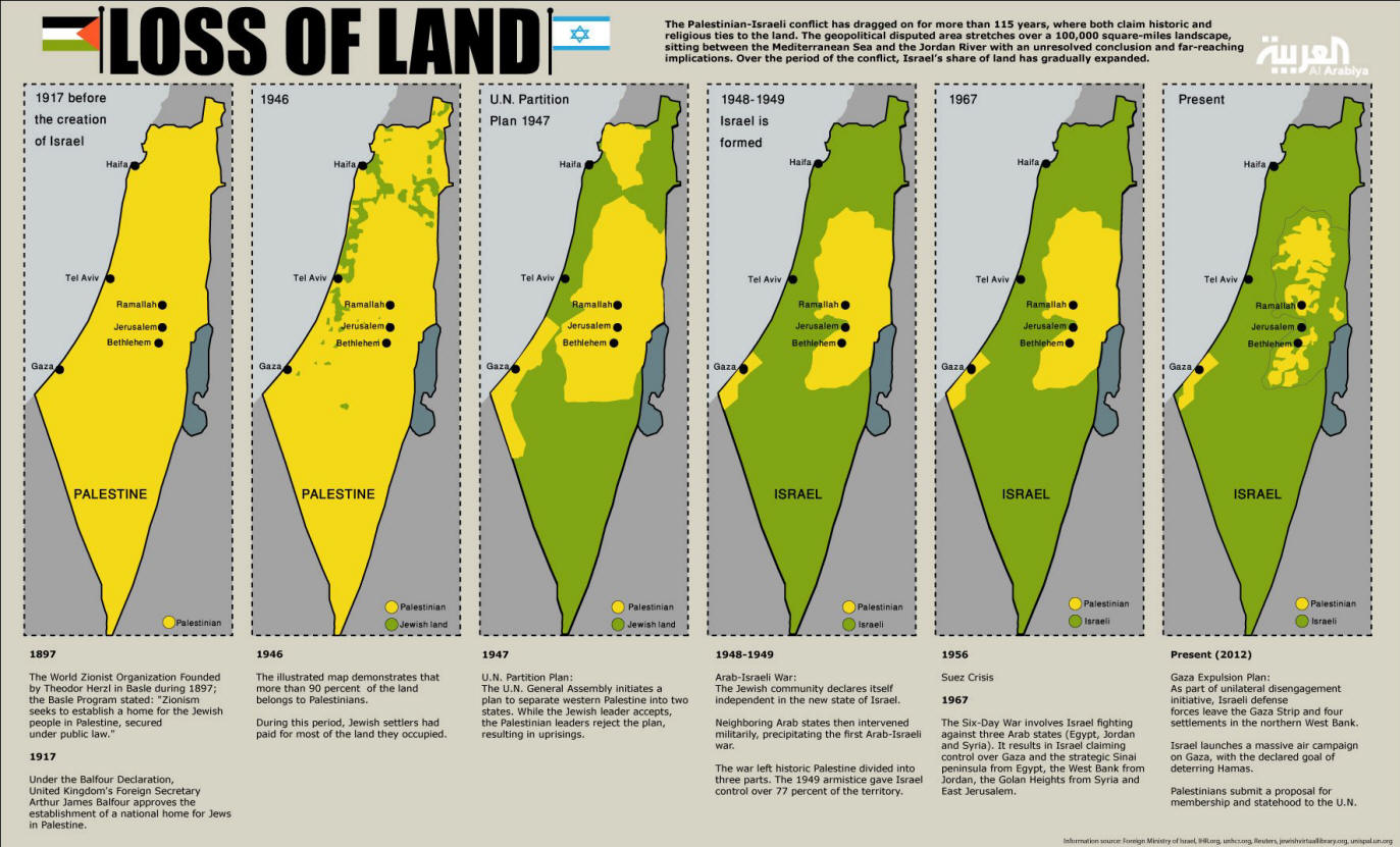
Zum Vergrößern die Karte
anklicken.
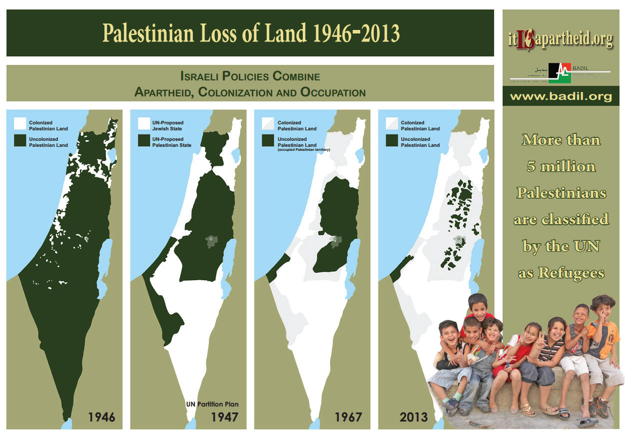
Zum Vergrößern die Karte
anklicken.
In noch besserer Auflösung - Quelle
>>>
Quelle
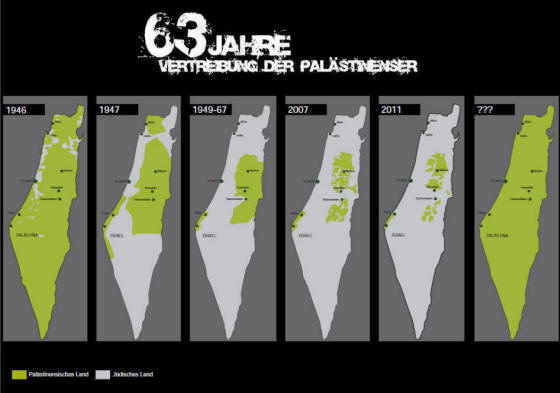
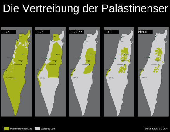
Yousef Taha -
Wunschtraum eines
Palästinensers -
http://www.falastin.de/
Zum Vergrößern die Karte
anklicken.
Zum Vergrößern die Karte
anklicken.
Zum Vergrößern die Karte
anklicken.
Zum Vergrößern die Karte
anklicken.
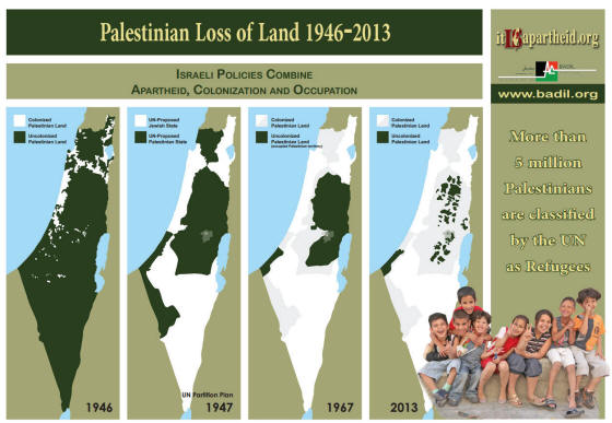
Zum Vergrößern kann man die meisten Karten anklicken.
Zum Vergrößern kann man die meisten
Karten anklicken.
Quelle
Quelle
Zum Vergrößern kann man die meisten
Karten anklicken.
Quelle
Zum Vergrößern kann man die meisten
Karten anklicken.
Quelle
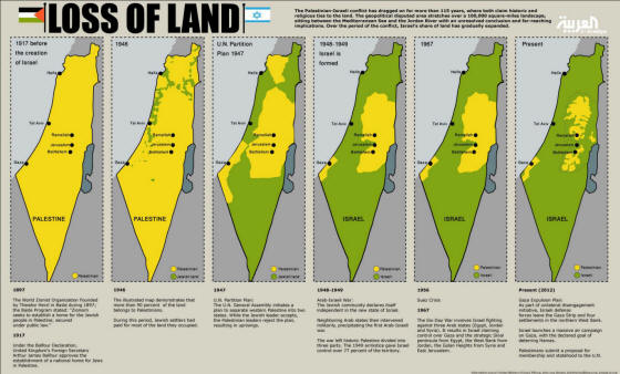
Destroing the Two-State Solution -
July 2005
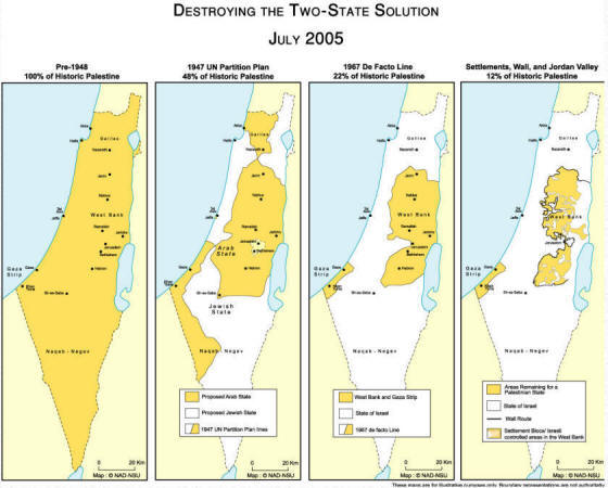
Original
Zum Vergrößern kann man die meisten
Karten anklicken.
Zum Vergrößern die Karte
anklicken.
http://go2.wordpress.com/?id=725X1342&site=thinkpress.wordpress.com&url=
http://thinkpress.files.wordpress.com/2010/05/palestine_map2.jpg&sref=
http://pulsemedia.org/2010/05/15/nakba-day-2010/
|


